风云全球瞰这里「南太平洋热带气旋“洛拉”监测」
来源: 发布日期:2023-10-242023年10月24日08时(北京时,下同)南太平洋热带气旋“洛拉”(LOLA)的中心位于瓦努阿图维拉港北偏东方向约360km的洋面上(北纬14.5度、东经169.0度),中心附近最大风力有17级以上(62m/s,相当于我国的超强台风级),中心气压为905hpa。
At 08:00 on October 24,2023 (Beijing Time, the same below), the center of the South Pacific tropical cyclone LOLA was located on the ocean about 360 kilometers (14.5°N , 169°E) east of Villa Port of Vanuatu. The maximum wind near the center was above 17 (62 m / s, equivalent to the super typhoon in China), and the central pressure was 905 hpa.
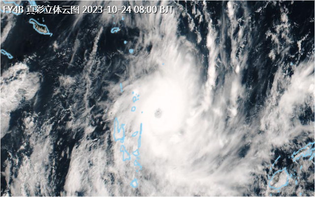
过去24小时,“洛拉”明显增强,中心附近最大风速由13级加强到17级以上。10月24日08:00的FY-4B卫星真彩色云图显示(图1):“洛拉”具有较明显的螺旋结构,眼区较清晰。
In the past 24 hours, LOLA has increased significantly, with the maximum wind speed near the center strengthening from level 13 to above level 17. The true color cloud map of FY-4B satellite at 08:00 on October 24 showed (Figure 1)that LOLA has a more obvious spiral structure and a clear eye area.

图1 FY-4B卫星真彩色云图(10月24日08时)
Figure 1. FY-4B satellite true color cloud map (08:00, October 24)
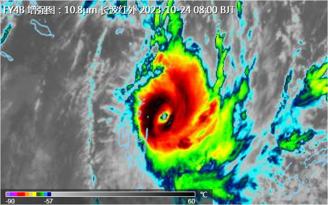
FY-4B卫星红外增强云图显示(图2),“洛拉”附近对流发展旺盛、云顶亮温低于-70℃。
According to the FY-4B satellite infrared enhanced cloud map (Figure 2), the convection near LOLA was booming and the bright temperature of the cloud top was lower than-70℃.

图2 FY-4B卫星红外增强云图(10月24日8时)
Figure 2. FY-4B IR Enhance (8:00, October 24)
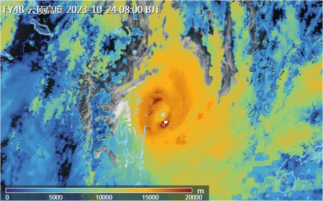
FY-4B卫星云顶高度监测产品显示(图3):08:00 “洛拉”中心附近地区上空对流云团云顶高度较高,达18km 以上。
FY-4B satellite cloud top height monitoring (Figure 3) showed that the cloud top height of the convective cloud over the area near the center of LOLA was high, reached more than 18km.

图3 FY-4B卫星云顶高度产品(10月24日8时)
Figure 3. FY-4B Cloud Top Height(8:00, October 24)
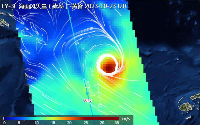
受“洛拉”影响瓦努阿图东北部洋面出现强风,FY-3E洋面风场产品(图4)显示, 10月23日14:40气旋中心附近风速超过35m/s,8级风圈半径超过了150km。
Due to the influence of LOLA, strong wind appeared on the ocean surface in the northeast of Vanuatu. FY-3E ocean wind field (Figure 4) showed that the wind speed near the center of the cyclone has exceeded 35m/s and the radius of the class 8 wind circle exceeded 150km at 14:40 on October 23.

图4 FY-3E洋面风场产品
Figure 4. FY-3E Ocean Surface Wind Field
预计,“洛拉”将以每小时10-15km左右的速度偏南方向移动,强度逐渐减弱,需关注“洛拉”给瓦努阿图和所罗门群岛等地带来的强风和暴雨影响。
It is expected that LOLA will move southward at a speed of about 10-15 kilometers per hour, gradually weakening in intensity, and pay attention to the impact of strong winds and heavy rain from LOLA to Vanuatu and the Solomon Islands.