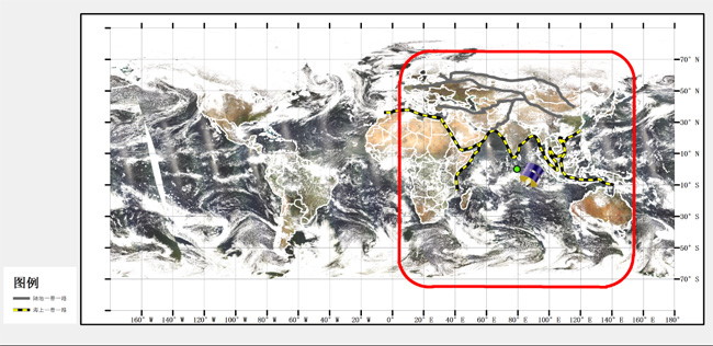
China Meteorological Administration (CMA) positioned Fengyun-2H (FY-2H) meteorological satellite at 79°E, which can provide continuous observation for Southern Asia, Western Asia, Central Asia, and most African countries. [Photo/National Satellite Meteorological Center of CMA]
BEIJING, July 22 (China Economic Net) – “The satellite data and meteorological data provided by China’s meteorological satellites can be used to monitor Pakistan’s desert locusts and provide early warnings to relevant parties,” source form China Meteorological Administration (CMA) said, adding that CMA has released special reports on remote sensing data of locust attacks in Pakistan.
“China’s Fengyun series satellites can generate information for analysis of locust-affected area by monitoring rainfall, soil moisture and land surface temperature (LST) changes of the African and South Asian countries,” CMA noted, explaining that a hotter and wetter climate favours more multiplication of locusts, and studies have also linked wind direction, speed, and other weather parameters to the migration of locusts.
According to an update issued by the Food and Agriculture Organisation (FAO) of the United Nations (UN), the summer breeding of desert locust swarms has commenced in Pakistan’s Tharparkar, Nara and Cholistan deserts where hatching and band formation will increase later this month.
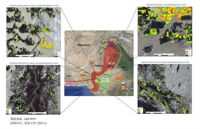
Fengyun satellites data is used to make remote sensing-based assessment on vegetation damage in Pakistan. [Photo/National Satellite Meteorological Center of CMA]
On top of monitoring the breeding and movement of locust swarm, Fengyun satellites are helpful when it comes to the assessment of vegetation damage. Locust swarms ravaged crops and pastureland, destroyed food and vegetation and jeopardized food security across Africa, the Arabian Peninsula, and parts of South Asia. Fengyun-3 (FY-3) polar orbit meteorological satellite, therefore, is used to monitor how the crops are growing. With the monitoring data generated by FY-3, Pakistani scientists can offer remote sensing-based assessment of vegetation damage in locust-invaded areas.
As per CMA, Pakistan Meteorological Department (PMD) has been using data collected from China’s CMACast, an updated satellite data broadcast system based on Digital Video Broadcasting - Satellite - Second Generation (DVB-S2) with both file and multimedia transmission capability since 2006; they have regularly posted maps sensed by Fengyun-2E (FY-2E) satellite online for various disaster prevention and mitigation authorities. In addition, data collected by China’s Meteorological Information Comprehensive Analysis and Process System (MICAPS) has been used by Pakistan to analyze and forecast weather for relevant institutions and the public.
China on June 5, 2018 launched FY-2H meteorological satellite to improve the accuracy of weather forecasting and provide better meteorological services to countries participating in the Belt and Road Initiative (BRI), CMA told China Economic Net. The number of countries using Fengyun satellites data has increased to 108 (including 75 countries involved to BRI) by May 2020, and 30 countries have established earth stations to transmit and receive information to and from Fengyun satellites.